Product modules
Seenic 3D Explorer
Immerse prospects in stunning 3D property models with aerial views, interactive unit selection, and amenity highlights.
Areas of use:
New developments
Existing properties

Aerial Views
Displays a high-level view of the property layout and surrounding structures. Users can toggle building highlights, check unit availability, and switch to a detailed 3D overview when needed. This macro perspective enables quick orientation for large or complex developments.
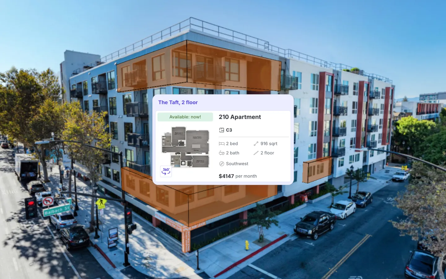
Unit-Level Selection
Offers filtered access to individual apartments or condos, including floor plans, unit dimensions, and current availability. Users can also view apartment features, launch virtual tours, or check balcony views—centrally consolidating all relevant data for each unit.

Neighborhood Map
Integrates an external map interface that shows key local amenities (groceries, transit stops, schools) in relation to the property. Users can apply filters, measure distances, or view ratings, allowing location-based evaluation without leaving the 3D Explorer environment.

Interactive Sitemap View
Serves as a 2D complement to the 3D Overview, particularly effective for large or irregular property layouts. Users can apply real-time filters, view sun position simulations, or click on specific buildings/floors/units. This flexibility addresses varied browsing preferences and streamlines property navigation.

Tooltips & Hotspots
Displays persistent labels for buildings and their available units, alongside clickable markers for amenities or neighborhood facilities. Tooltips provide immediate context, while hotspots link to additional media or details—reducing navigation friction and enhancing user engagement.

Online Availability
Provides real-time visibility into which units are currently open for lease or sale and when they can be occupied. The system automatically updates pricing or status changes—via direct property management integration or manual entries—so users see accurate information at all times. This transparency supports faster decision-making and eliminates repeated status inquiries.
Engrain & Matterport Integrations
Leverages two widely adopted real estate solutions to expand 3D Explorer’s capabilities. Engrain delivers advanced interactive site maps for tracking availability, while Matterport offers immersive 360° tours. Both can be unified into a single guided experience, creating a seamless path from overview to in-depth walk-through.


Own Content Integration
Enables direct upload of photos or videos for any unit, even if it’s still occupied. This ensures a basic visual reference is always available for prospective renters or buyers—without waiting for vacancy. By housing all media in one place, teams can market units more effectively.

Interactive 3D Floor Plans
Presents a cost-effective way to visualize unit layouts, featuring an optional 360° spinner and integrated virtual tour. Users can explore from multiple angles—top-down, rotational, or fully immersive—providing three levels of depth. This structure clarifies room dimensions and overall flow before any in-person appointment.

Guided Tours
Offers live or recorded sessions within the 3D Explorer, letting an agent guide viewers through top features, answer questions in real time, and spotlight selected units or amenities. This approach consolidates remote showings and promotions into a single, streamlined platform.